![](/images/other/stat-length.png)
![Trail Walking Plateau d'Hauteville - 2020-03-04 Plan d'eau des Lésines - Photo](https://media.geolcdn.com/t/1900/400/ext.pjpeg?maxdim=2&url=https%3A%2F%2Fstatic1.geolcdn.com%2Fsiteimages%2Fupload%2Ffiles%2F1553511878bg_sport_marche.png)
2020-03-04 Plan d'eau des Lésines
patpounet73
User
![Length](/images/other/stat-length.png)
Length
8.1 km
![Max alt](https://static1.geolcdn.com/siteimages/upload/files/1508320355ic_sort_altitude_max_24dp.png)
Max alt
828 m
![Uphill gradient](https://static1.geolcdn.com/siteimages/upload/files/1508320355ic_sort_den_pos_24dp.png)
Uphill gradient
139 m
![Km-Effort](/images/other/stat-length.png)
Km-Effort
9.9 km
![Min alt](https://static1.geolcdn.com/siteimages/upload/files/1508320355ic_sort_altitude_min_24dp.png)
Min alt
733 m
![Downhill gradient](https://static1.geolcdn.com/siteimages/upload/files/1508320355ic_sort_den_neg_24dp.png)
Downhill gradient
140 m
![Boucle](https://static1.geolcdn.com/siteimages/upload/files/16400158638029165_repeat_loop_refresh_sync_direction_icon.png)
Boucle
Yes
Creation date :
2020-03-04 14:38:15.513
Updated on :
2020-03-05 09:17:31.046
![Walking](https://static1.geolcdn.com/sitytour/trail-icons/101.png)
2h00
Difficulty : Easy
![Scan this QR Code to open this trail in the SityTrail application](https://capi.geolives.com/qq0zvz2zws4bq2lad0pu/sitytour/trails/2353863/qr.png?size=200)
FREE GPS app for hiking
About
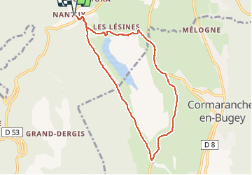
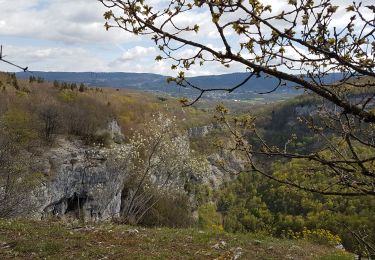
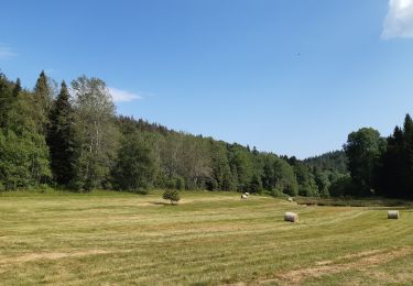
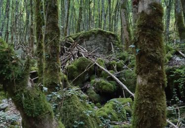
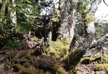
Trail Walking of 8.1 km to be discovered at Auvergne-Rhône-Alpes, Ain, Plateau d'Hauteville. This trail is proposed by patpounet73.
Description
Le temps est couvert, c'est pourquoi nous avons fait la boucle en marche rapide. Prévoir 3h00 pour profiter de ce circuit agréable qui ne présente aucune difficulté.
Positioning
Country:
France
Region :
Auvergne-Rhône-Alpes
Department/Province :
Ain
Municipality :
Plateau d'Hauteville
Location:
Hauteville-Lompnes
Start:(Dec)
Start:(UTM)
699559 ; 5093718 (31T) N.
Comments
Trails nearby
![Trail Mountain bike Plateau d'Hauteville - Espace VTT FFC du Bugey - Circuit n° 01 - Photo](https://media.geolcdn.com/t/375/260/ext.jpg?maxdim=2&url=https%3A%2F%2Fservices.sitytrail.com%2FGeolivesWS%2FDownloadMedia.ashx%3FTrailID%3D101872%26Media%3D2159_1.jpg)
![Mountain bike Mountain bike](https://static1.geolcdn.com/sitytour/trail-icons/202.png)
Espace VTT FFC du Bugey - Circuit n° 01
Mountain bike
Easy
(1)
Plateau d'Hauteville,
Auvergne-Rhône-Alpes,
Ain,
France
![](/images/other/stat-length.png)
12.5 km | 15.2 km-effort
1h 0min
![](https://static1.geolcdn.com/siteimages/upload/files/16400158638029165_repeat_loop_refresh_sync_direction_icon.png)
Yes
![Trail Walking Plateau d'Hauteville - 01 Hautville Belvédère Planachat - Photo](https://media.geolcdn.com/t/375/260/ext.jpg?maxdim=2&url=https%3A%2F%2Fstatic1.geolcdn.com%2Fsiteimages%2Fupload%2Ffiles%2F1553511878bg_sport_marche.png)
![Walking Walking](https://static1.geolcdn.com/sitytour/trail-icons/101.png)
01 Hautville Belvédère Planachat
Walking
Difficult
(1)
Plateau d'Hauteville,
Auvergne-Rhône-Alpes,
Ain,
France
![](/images/other/stat-length.png)
10.8 km | 17.1 km-effort
3h 53min
![](https://static1.geolcdn.com/siteimages/upload/files/16400158638029165_repeat_loop_refresh_sync_direction_icon.png)
Yes
![Trail Nordic walking Plateau d'Hauteville - cormaranche 20220326 - Photo](https://media.geolcdn.com/t/375/260/ext.jpg?maxdim=2&url=https%3A%2F%2Fmedia.geolcdn.com%2Ff%2Fc23bf53a-5142-45d1-b749-fa8e16ce1231.jpg)
![Nordic walking Nordic walking](https://static1.geolcdn.com/sitytour/trail-icons/102.png)
cormaranche 20220326
Nordic walking
Difficult
Plateau d'Hauteville,
Auvergne-Rhône-Alpes,
Ain,
France
![](/images/other/stat-length.png)
11.4 km | 20 km-effort
2h 23min
![](https://static1.geolcdn.com/siteimages/upload/files/16400158638029165_repeat_loop_refresh_sync_direction_icon.png)
No
![Trail Nordic walking Plateau d'Hauteville - cormaranche20220321 - Photo](https://media.geolcdn.com/t/375/260/ext.jpg?maxdim=2&url=https%3A%2F%2Fmedia.geolcdn.com%2Ff%2F006a3545-b0f2-4e00-bf7b-e5599191d1d6.jpg)
![Nordic walking Nordic walking](https://static1.geolcdn.com/sitytour/trail-icons/102.png)
cormaranche20220321
Nordic walking
Difficult
Plateau d'Hauteville,
Auvergne-Rhône-Alpes,
Ain,
France
![](/images/other/stat-length.png)
7.1 km | 12.9 km-effort
1h 17min
![](https://static1.geolcdn.com/siteimages/upload/files/16400158638029165_repeat_loop_refresh_sync_direction_icon.png)
Yes
![Trail Walking Plateau d'Hauteville - Planachat - Photo](https://media.geolcdn.com/t/375/260/ext.jpg?maxdim=2&url=https%3A%2F%2Fservices.sitytrail.com%2FGeolivesWS%2FDownloadMedia.ashx%3FTrailID%3D42061%26Media%3Dimage5.jpg)
![Walking Walking](https://static1.geolcdn.com/sitytour/trail-icons/101.png)
Planachat
Walking
Very easy
(1)
Plateau d'Hauteville,
Auvergne-Rhône-Alpes,
Ain,
France
![](/images/other/stat-length.png)
7.8 km | 12.3 km-effort
1h 49min
![](https://static1.geolcdn.com/siteimages/upload/files/16400158638029165_repeat_loop_refresh_sync_direction_icon.png)
Yes
![Trail Walking Plateau d'Hauteville - Nantuy La Berche - Photo](https://media.geolcdn.com/t/375/260/ext.jpg?maxdim=2&url=https%3A%2F%2Fmedia.geolcdn.com%2Ff%2Fd8589a16-c9ea-4909-9799-d99681ccb007.jpg)
![Walking Walking](https://static1.geolcdn.com/sitytour/trail-icons/101.png)
Nantuy La Berche
Walking
Medium
Plateau d'Hauteville,
Auvergne-Rhône-Alpes,
Ain,
France
![](/images/other/stat-length.png)
15.3 km | 21 km-effort
4h 31min
![](https://static1.geolcdn.com/siteimages/upload/files/16400158638029165_repeat_loop_refresh_sync_direction_icon.png)
Yes
![Trail Walking Plateau d'Hauteville - Chemin de crête de Valorse - Photo](https://media.geolcdn.com/t/375/260/ext.jpg?maxdim=2&url=https%3A%2F%2Fmedia.geolcdn.com%2Ff%2Fcb405710-9611-4e37-ab00-4c6b5ca1dd4d.jpg)
![Walking Walking](https://static1.geolcdn.com/sitytour/trail-icons/101.png)
Chemin de crête de Valorse
Walking
Medium
Plateau d'Hauteville,
Auvergne-Rhône-Alpes,
Ain,
France
![](/images/other/stat-length.png)
4.7 km | 6.2 km-effort
1h 41min
![](https://static1.geolcdn.com/siteimages/upload/files/16400158638029165_repeat_loop_refresh_sync_direction_icon.png)
Yes
![Trail Walking Chaley - Albarine à Chaley - Photo](https://media.geolcdn.com/t/375/260/ext.jpg?maxdim=2&url=https%3A%2F%2Fmedia.geolcdn.com%2Ff%2F04f934c9-c846-458a-83c5-98abc05198c1.jpg)
![Walking Walking](https://static1.geolcdn.com/sitytour/trail-icons/101.png)
Albarine à Chaley
Walking
Very easy
Chaley,
Auvergne-Rhône-Alpes,
Ain,
France
![](/images/other/stat-length.png)
5.9 km | 7.4 km-effort
2h 57min
![](https://static1.geolcdn.com/siteimages/upload/files/16400158638029165_repeat_loop_refresh_sync_direction_icon.png)
Yes
![Trail Walking Plateau d'Hauteville - Chemin des Crêtes La Praille - Photo](https://media.geolcdn.com/t/375/260/ext.jpg?maxdim=2&url=https%3A%2F%2Fmedia.geolcdn.com%2Ff%2F8dc776ce-fe51-4c6a-9fae-b4fd9b27fa75.jpg)
![Walking Walking](https://static1.geolcdn.com/sitytour/trail-icons/101.png)
Chemin des Crêtes La Praille
Walking
Medium
Plateau d'Hauteville,
Auvergne-Rhône-Alpes,
Ain,
France
![](/images/other/stat-length.png)
5.6 km | 7.8 km-effort
2h 1min
![](https://static1.geolcdn.com/siteimages/upload/files/16400158638029165_repeat_loop_refresh_sync_direction_icon.png)
Yes